| Main objective / mission |
The objective of this PD is to provide innovative hazard maps with uncertainty, and overcoming the current limits of PVHA imposed so far by the high computational cost required to adequately simulate complex volcanic phenomena (such as tephra dispersal) while fully exploring the natural variability associated to such volcanic phenomena, on a country-size domain (~thousands of km) at a high resolution (one to few km).
We focus on the case of tephra hazard assessment, both in terms of tephra accumulated at the ground and airborne tephra concentration: to achieve unbiased PVHA it is mandatory to account for the natural variability linked to the eruption scale or type, the consequent Eruptive Source Parameters (ESP), the position of eruptive vents, and the wind field. This translates into a large number of numerical simulation for tephra transport and deposition, on a large-scale domain, that we perform with the flagship code Fall3D optimized in ChEESE.
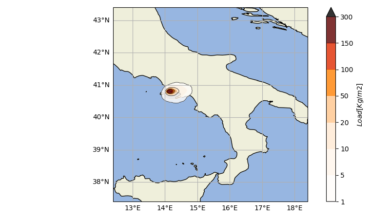
In this PD, we are proposing two types of Probabilistic Volcanic Hazard Assessment (PVHA), that may become services: short- (days to weeks) and long-term (years to decades) PVHA. Further, we focus on two target volcanic systems: Campi Flegrei caldera, in Southern Italy, located in one of the most populated areas in Europe and characterized by a long-lasting unrest (since 2004), and Jan Mayen In North Atlantic (Norway), a little island located on the highest-traffic air routes between Europe and North America.
The short-term PVHA is proposed as an illustrative example at the Campi Flegrei volcano, on a particular set of dates (5 to 7 December 2019), when an earthquake of magnitude 3.1 was located in the caldera. The long-term hazard assessment is proposed both for Campi Flegrei (for ground tephra accumulation and airborne ash concentration), and Jan Mayen island (for the airborne ash concentration only). |
| Workflow description |
PVHA_WF_st fetches the monitoring data (seismic and deformation) and, together with the configuration file of the
volcano, calculates the eruptive forecasting (probability curves and vent opening positions) and uses the output file from alphabeta_MPI.py to create the volcanic hazard probabilities and maps.
PVHA_WF_lt uses the configuration file of the volcano to calculate the eruptive forecasting and, together with the output file from alphabeta_MPI.py, creates the volcanic hazard
probabilities and maps.
Meteo data download process is fully automated. PVHA_WF_st and PVHA_WF_lt connect to the Climate Data Store (Copernicus data server) and download the meteorological data associated with a specified analysis grid. These data will later be used to obtain the results of tephra deposition by FALL3D. |
| Target TRL |
6 or 7
View TRL chart
A live exercise to prove the feasibility of using PD6 to produce useful impact assessment of tephra ground load at the scale of a country has been developed for Campi Flegrei, Italy, in collaboration with ARISTOTLE and PLINIVS as stakeholders. The objective of PD6 exercise was to show the feasibility and usefulness of short-term probabilistic assessment of volcanic tephra hazard in an operational environment, with the added value (enabled by HPC) of an assessment over a large-scale domain and considering the uncertainty associated with the eruption size parameters. The operational challenges were dealing with real time performance of the PD6 distributed workflow, fetching real-time monitoring data from Osservatorio Vesuviano surveillance system, processing them at INGV Bologna on the computer cluster ADA, fetching weather forecast from GFS and processing them at INGV Bologna, running tephra dispersal simulations with the Flagship code Fall3D on MareNostrum 4 at BSC, and handling the output from the above on ADA cluster at INGV-Bologna to produce hazard assessment for the end-users.
|
| Achievements up to M41 |
- The award of PRACE resources, in association with PD3 and PD12, to run FALL3d simulations at the required
- target resolution and spatial domain
- The prototypal version of PVHA_WF to process the simulations and produce hazard maps
- The application of PVHA_WF to the case of Campi Flegrei volcano, in Southern Italy, in an illustrative example for the days 5, 6 and 7 December 2019, to show the proof-of-concept and feasibility
|