News
ChEESE and POP: A recipe for success
21 November 2019
Claudia Rosas and Mauricio Hanzich - ChEESE and POP webinar


ChEESE researchers Mauricio Hanzich and Claudia Rosas from the Barcelona Supercomputing Center presented a webinar titled "12th POP User Webinar - The Successful Interaction of ChEESE and POP" on November 12, 2019. The webinar focused on the work of ChEESE in integrating HPC and data across Solid Earth related disciplines in Europe and how POP conducts performance assessments on all the codes that ChEESE uses.

About the presenters: 

Claudia Rosas has been a Post Doc in the Computer Applications for Science and Engineering department of Barcelona Supercomputing Center since 2016, with about 10 years’ experience in software engineering and performance analysis and optimization.

Mauricio Hanzich leads the Software Development group at the Computer Applications for Science and Engineering department of Barcelona Supercomputing Center. His main focus is software research and development for the oil industry, with broad experience in the development of HPC software for the whole stack, from the hardware to the application level.

View the webinar:


News
Volcanic hazards startup MITIGA Solutions uses ChEESE technology for air traffic management
14 November 2019
MITIGA Solutions image


About 90% of the most in-demand flights travel over high-risk volcanic areas. On average, ash-forming eruptions cost more than $500 million in losses per year to airlines, and eventually billions of dollars to related aviation stakeholders (engine manufacturers, insurance, service providers). Atmospheric dispersion of hazardous substances influences many economic markets and poses a variety of problems to different segments of the aviation industry. In the last decade, regulation frameworks for air navigation changed to allow airlines to decide whether to operate under volcanic ash contaminated airspace and the European Aviation Safety Agency (EASA) has required engine manufacturers to certify engine susceptibility to volcanic ash and other hazardous pollutants. In this context, a gap exists between available information on dispersion of hazardous substances and industry needs at operational level, creating a market opportunity. Aeronautics is one of the EU’s key high-tech sectors in the global market. It generates around €220 billion, providing 4.5 million direct and indirect jobs. The European Union is a world leader in aerospace products and aeronautical technologies are catalysts for innovation contributing to the growth of the EU economy as a whole.

MITIGA Solutions is a spin-off of the Barcelona Supercomputing Center (BSC), the national supercomputing facility in Spain, the coordinator of the ChEESE CoE, and a world-renowned institution with extensive experience in developing and implementing supercomputer models in the fields of geophysics, volcanology and atmospheric impacts.

MITIGA has developed an Impact Calculation Engine (ICE), that is being used in an in-house operational high performance computing (HPC) software. It is capable of providing customer-based commercial solutions for air traffic management (ATM) during hazardous scenarios caused by the presence of volcanic ash and other aerosols in the atmosphere.

Inside of ChEESE CoE, there are different defined pilot demonstrators (PD) and codes that are related to volcanic ash clouds dispersion. Some of them may have a direct impact on MITIGA’s services quality:

  • Enhanced ash dispersion model. Fall3D is a well-established, ash-dispersion model developed in-house at BSC for the last 15 years. V8 of Fall3D was developed from ChEESE CoE and is now being integrated as an open source model into daily operations in MITIGA. The new model is faster, more scalable and more precise than V7 and will enable a better service for ATM customers.
  • Enhanced volcanic ash plume modelization. Besides the meteorological conditions, to properly model the actual eruption plume is of fundamental value for a proper dispersion modeling of an actual ash cloud. PD3 in ChEESE is devoted to coupling both ASHEE plume modeler with Fall3D. The goal is to produce better input parameters to Fall3D by properly modeling the ash plume with ASHEE. If the turnaround time for such a coupling is small enough, another step towards better ash dispersal simulations may be done in MITIGA’s operations and services for ATM.
  • High-resolution volcanic ash dispersal. PD12 in ChEESE is devoted to increase the resolution of the ash dispersal modeling by means of an ensemble-based data assimilation system. Such system will combine an Ensemble Transform Kalman Filter (ETKF) and the Fall3D ash dispersal model. The resulting models should improve the resolution of current operational models up to one order of magnitude. Yet again, this may positively impact MITIGA services for ATM.
  • Probabilistic volcanic hazard assessment (PVHA). On one hand, among MITIGA activities there are some related to the insurance sector and the effect of volcanic eruptions on it. Currently, MITIGA is working on a Cat-Bond product for the international Red Cross. This product is partially based on a Population and Habitat Viability Assessment (PVHA) task. On the other hand, PD6 in ChEESE is devoted to PVHA and some synergies may arise from it as it is more general than what is currently being done at MITIGA.
News
Using High Performance computing for simulating local tsunami hazard
16 August 2019
ChEESE

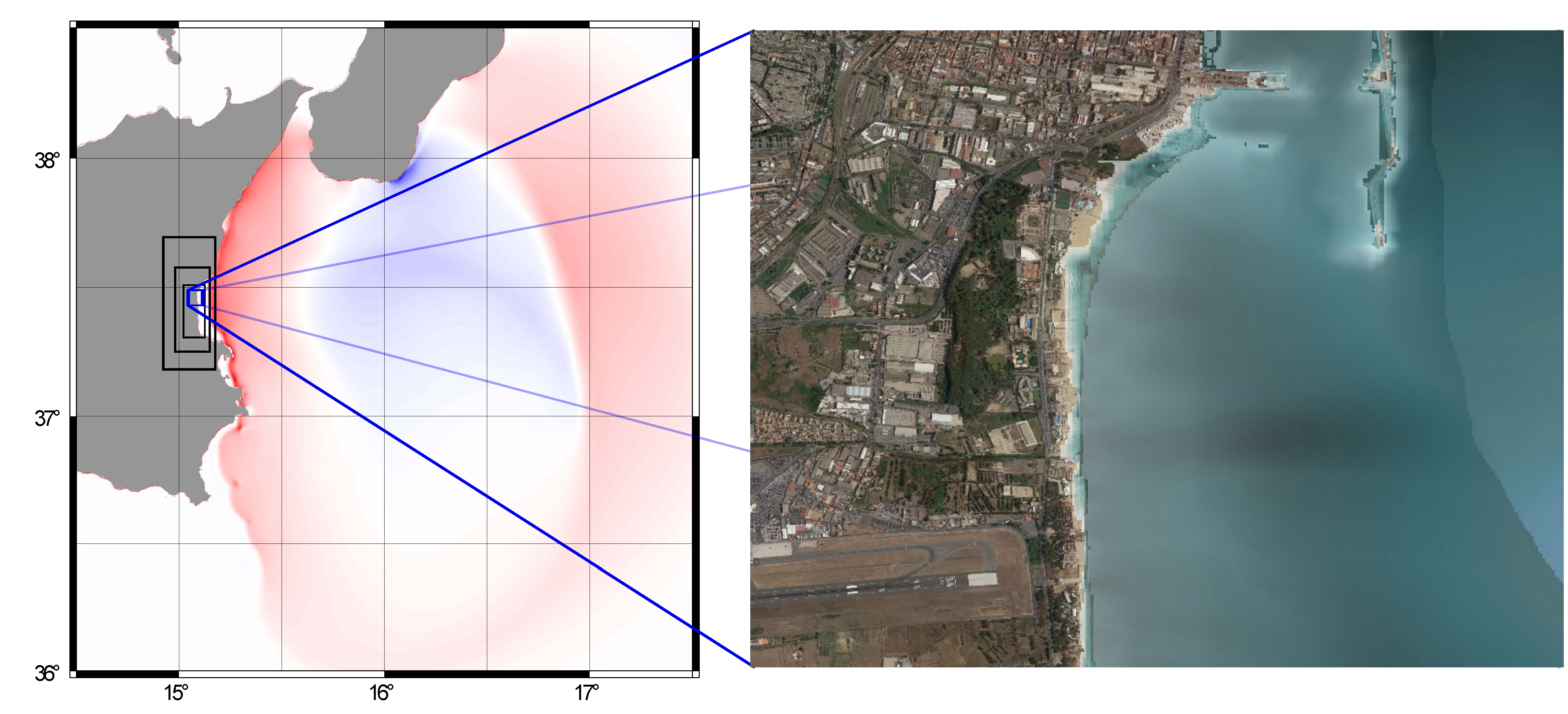
Figure 1: Left, simulation of a tsunami propagating from the Calabrian Arc towards southern Italy. Right, tsunami inundation using a high-resolution map towards an area offshore Catania, Italy. In ChEESE, we will use High Performance Computing to simulate thousands of these kinds of scenarios and use these to represent the coastal tsunami hazard at high resolution.


Tsunamis are long water waves caused by other large natural hazards such as earthquakes, landslides, and volcanoes. They present a threat to near-coastal populations and infrastructure. In ChEESE, new ways of quantifying tsunami hazard will be developed. The main aim is to utilize large High Performance Computing resources to map the tsunami inundation hazard at very high resolution while, at the same time, estimating the large uncertainty associated with tsunamis.

Tsunami hazard analysis tells us how probable it is for an area to be inundated by a tsunami of a given size. Tsunamis of moderate run-up height inundating smaller areas are more frequent, while tsunami with high run-up inundating large areas are less frequent. The frequency of the tsunamis is tightly linked to the frequency of their sources. The most common source is earthquakes.

The uncertainty related to the occurrence probability of any tsunami source is large. Because tsunamis are too infrequent to use data directly to represent the hazard, we need models to do it. To cover the source uncertainty, we need to model tsunamis due to many, often tens to hundreds of thousands of sources. For this, we need High Performance Computing resources.

The most severe tsunami impact may occur locally just after the event has been triggered, but tsunamis can also cause damage several hours after they are generated. Moreover, tsunami wavelengths range from hundreds of kilometres in the open ocean, to a few meters when a tsunami inundates the coastlines. Therefore, tsunami modelling needs to involve a wide range of spatial scales, over a simulation that can span several tens of hours. This, combined with the need for carrying out a huge number of simulations, necessitates extreme computing power.

The most elaborate previous tsunami hazard analyses have so far been carried out on a regional level, and are hence not sufficiently accurate for modelling inundation and map the hazard in detail. In ChEESE, High Performance Computing allows us to model tsunami hazard at high resolution using a sufficient number of potential tsunami sources. Using exascale computing, we can combine a rigorous representation of the tsunami uncertainty with high resolution inundation maps. This will form the background for a next generation of tsunami hazard maps with higher accuracy and better uncertainty representation than is possible using today's methods.In ChEESE, we plan to develop a service that can help users to carry out local hazard studies in their own environment. The service will initially be limited to the Mediterranean Sea, and will let users upload their own high resolution local topography grid for a coastal site to perform hazard mapping. The service will utilize an already existing coarser grained regional tsunami hazard assessment (TSUMAPS-NEAM, http://www.tsumaps-neam.eu/) as the input for setting up the local hazard study. Based on the location of the site, and the hazard level of interest, the service will select the scenarios that are expected to contribute most strongly to the hazard and use High Performance Computing to simulate the inundation from these scenarios.